|
|
|
|
|
|
|
|
|
|
|
|
 |
|
Pitty that Stockholm is so far away. But it's possible to go there avoiding all highways. No problems with highways when riding a Vincent, but You can choose smaller roads where You can have a pleasant ride and experience more.
Even if You don't go to the Scandinavian Rally this year, maybe You might have use of these suggestions another year. |
|
|
|
|
|
|
|
Svensk text |
|
|
|
|
|
 |
|
|
|
|
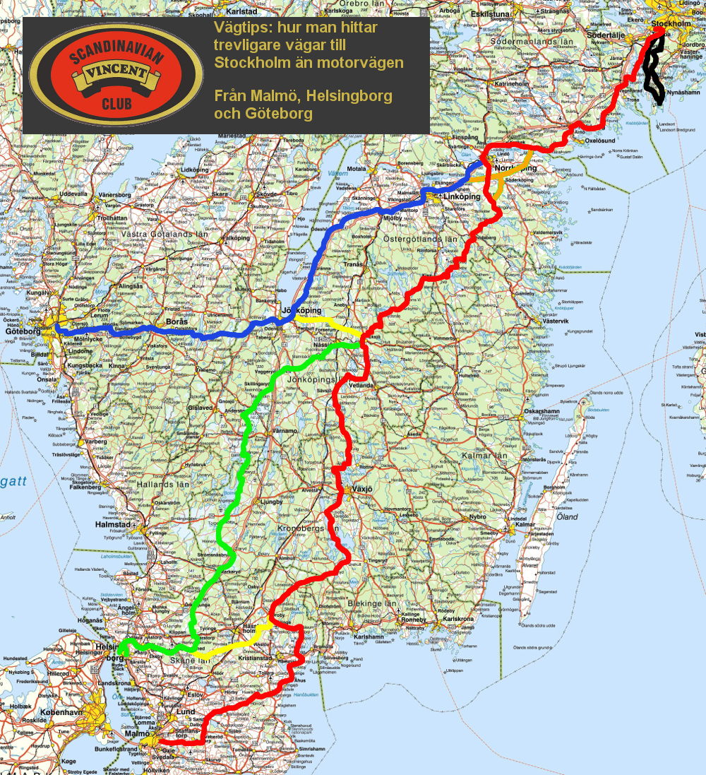
| All roads go toStockholm. Here is 3 to choose. |
| Red route. From Malmö to Stockholm across Åhus, Eksjö and Kolmården. Ferry from Mörkö. Many castles to be passed, especially in Skåne. |
 |
| Green route. Fom Helsingborg thrugh Söderåsen National Park and High Chaparral. From Eksjö joining the Red Route. |
 |
| Blue route. From Gothenburg via the old Riks-one from Jönköping along the lake Vättern. Joining the Red Route from Norrköping. |
 |
| Yellow shortcut. If You are going the Green or Blue Route, but want to continue at the Red Route, You can take one of the yellow Shortcuts. |
See the map for Your route |
| Orange shortcut. If You want to awoid the highway around Norrköping You can choose the Orange Shortcut via Söderköping and ferry across Bråviken. |
See the map for Your route |
|
|
|
|
|
|
|
|
|
| There are also maps from previous meets. |
| From 2015 when the meet was in Olofström (Fritzatorpet) |
| Ystad to Olofström |

|
| Malmö to Olofström |

|
| Helsingborg to Olofström |

|
| Borås to Olofström |

|
| Varberg to Olofström |

|
| Mjölby/Norrköping to Olofström |

|
| Värnamo/Vrigstad to Olofström |

|
| Places of interest around Olofström |

|
| From 2016 when the meet was in Fleninge (Fleninge Motel) |
| From the south, Malmö to Helsingborg |

|
| From the east, Örkelljunga to Helsingborg |

|
| From the north, Halmstad to Helsingborg |

|
| Places of interest around Helsingborg |

|
|
|
|
|
Those maps are some years old now, so there is a danger that some advices might no longer be proper. Some restaurants might be closed. |
|
|
 |
|
|
|
 |
|
|
|
|
